


Tuesday September 20, 2022 | VICTORIA, BC
by Mary P Brooke, B.Sc. | Island Social Trends
The Capital Region Tsunami Information Portal to empower residents and visitors to make informed emergency preparedness plans and keep people safe during a tsunami was launched today by the Province and the Capital Regional District (CRD).
Residents and visitors of the Capital Region can visit the Tsunami Information Portal at PrepareYourself.ca to see if they are residing, working in, or visiting a tsunami hazard zone. Knowing the tsunami zones helps prepare now to act later in the event of a tsunami following an earthquake.
Key points:
During today’s presentation to media a few points were clear:
- Know if you live or work in a tsunami-risk zone (mostly along the coast, and notably in Sooke, Port Renfrew, Esquimalt, and parts of Saanich) and prepare for tsunami-risk accordingly.
- If you feel the earth shaking, move to higher ground as soon as the shaking stops.
- If you are in a house or vacation property at the shoreline, it’s unlikely the structure will hold — best to evacuate.
- Small earthquakes are happening every day on Vancouver Island. It’s the big ones — subduction type reaching Magnitude 9 — that will produce tsunamis.
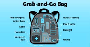
- Everyone should have an emergency kit and grab-and-go bag ready for emergencies of any type at any time.
Quake vs tsunami:
The capital region is an at-risk area to tsunami hazards from several potential sources including the Cascadian Subduction Zone, the Alaska-Aleutian Subduction Zone and local shallow crustal faults. However, as demonstrated by the portal, the majority of the capital region’s coastline is elevated with a limited risk of tsunami, and a majority of the region is at minimal risk or no risk of a tele-tsunami (distant tsunami).
The main tsunami risk in the capital region is from a felt earthquake. In the event of a felt earthquake, people located in a hazard zone should move outside the hazard zone immediately once the shaking stops. People already outside a hazard zone should remain there and be prepared to assist family and friends who need shelter.
Prepare for tsunami risk:
To prepare for a tsunami risk, people living and working in tsunami hazard zones are encouraged to practice their evacuation routes on foot or bike with family, friends or colleagues. Most people will not need to travel far to reach safety. Additionally, people are encouraged to prepare by making a home emergency plan and gathering supplies to build a home emergency kit and grab-and-go bags.
Creating the info portal:
The tsunami information portal was created by GeoBC using a coastal flood inundation modelling and mapping report developed by Associated Engineering, DHI and Westmar Advisors with funding from the federal and provincial National Disaster Mitigation Program.
The project was developed with input from local governments and First Nations across the capital region, and provincial, federal, community and academic partners.
Today one of the presenters acknowledged “dozens of regional partners and hundreds of people who shared their expertise” in order to produce this new portal for public use.
Direct link to the CRD Tsunami Information Portal.
Regional Emergency Management:
The Capital Region Tsunami Information Portal is a Regional Emergency Management Partnership (REMP) initiative. The REMP provided project management support for developing the information portal and partnered with GeoBC to create the tool enabling residents and visitors to understand the distribution of tsunami risk across the capital region.
Established in 2016 on behalf of the 13 municipalities and three electoral areas, the REMP is a 50/50 partnership between the Government of BC and the Capital Regional District. The REMP works on behalf of its member municipalities and electoral areas to enhance regional emergency management planning across the CRD.
Juan de Fuca area:
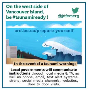
On the west coast of Vancouver Island, the Juan de Fuca Emergency Program is actively involved in supporting emergency preparedness awareness in the region. That includes East Sooke, and west of Sooke (including Otter Point, Jordan River, and Port Renfrew).
The Juan de Fuca Emergency Program Coordinator is Jeri Grant. Her office can be reached by email at jdfepc@crd.bc.ca .

=====Learn more (government links):
Capital Region Tsunami Information Portal: http://maps.prepareyourself.ca
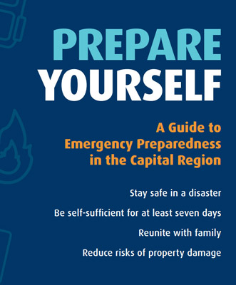
Prepare Yourself: A Guide to Emergency Preparedness in the Capital Region: https://www.crd.bc.ca/docs/default-source/prepareyourself/epworkbook-ed4.pdf?sfvrsn=a2526dca_16
The Capital Region Flood Inundation Mapping Project: https://www.crd.bc.ca/about/data/climate-change/coastal-flood-inundation-mapping-project