


Thursday April 11, 2024 | VICTORIA, BC
by Mary P Brooke | Island Social Trends
High Ground Hike is a multi-day community event held during Tsunami Preparedness Week. This year, Tsunami Preparedness Week is from April 14 to 20.
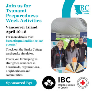
The BC Earthquake Alliance works to build a culture of earthquake and tsunami preparedness, through efforts such as the Great British Columbia ShakeOut.
The purpose is to raise awareness about B.C.’s tsunami risk and give coastal residents an opportunity to practice reaching their tsunami safe zone.
If you’re near the coast:
If you feel an earthquake, and you’re at the coast in an area without evacuation maps, plans or cell service, immediately move as high or far inland (away from the water) as possible.
If you live in an at-risk community with evacuation plans:
- Move to high ground following your designated tsunami evacuation route
- Follow all instructions from local officials
- Stay on higher ground until you receive the “all clear” message from your local authority, tsunami waves can last several hours
- Never go to the beach to watch the waves. A tsunami can move faster than you can run
Learn more about tsunami preparedness at PreparedBC.ca/tsunamis
Vancouver Island events in 2024:
There are some tsunami hike events coming up:
- Tofino: April 13
- Bamfield: April 14
- Metchosin April 15 (6 pm): Join the High Ground Hike on April 15 at 6 pm – groups will be meeting at Taylor Beach, Tower Point and Sandgate beach points (check with your PODs to coordinate). If you’re near the coast when an earthquake occurs, immediately Drop, Cover, Hold On. Once the shaking stops, move to higher ground to protect yourself from a potential tsunami. Now it’s time to practice!
- Sooke: April 18
- Colwood: April 19. 10 am to 12 noon. Hike to high ground with members of Royal Roads University (RRU) and Colwood communities. Hosted by the City of Colwood and RRU, the event will provide attendees with the opportunity to practice what to do in the event of a real tsunami. Colwood Fire Rescue personnel will be on hand to answer questions, showcase emergency equipment and display area tsunami evacuation maps. Booths will be set up along the hiking trail for participants to learn more about programs and services aimed at empowering and educating residents about emergency preparedness. On-leash pets ok. Participants may arrive at Lower Parking and complete the hike at any time during the 2-hour event. Estimated time to complete the hike, including stopping at booths, is 15-20 minutes.
- Salt Spring Island: April 19

Tsunami Notification Zones:
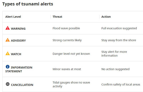
Coastal communities are divided into five tsunami notification zones. Knowing your zone will help when a Warning, Advisory or Watch is issued for your area.
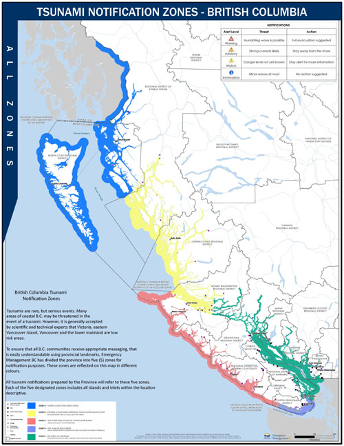
The Emergency Management folks at the BC Government suggest using the maps below to identify your zone then check in with your local authority about your community’s tsunami plan, evacuation routes and high ground locations.
Tsunami Notification Zone A – map (PDF, 2.6MB)
- North coast and Haida Gwaii
Tsunami Notification Zone B – map (PDF, 3.5MB)
- Central coast and northeast Vancouver Island coast including Kitimat, Bella Coola, and Port Hardy
Tsunami Notification Zone C – map (PDF, 4.2MB)
- West coast of Vancouver Island from Cape Scott to Port Renfrew
Tsunami Notification Zone D – map (PDF, 1.8MB)
- Juan de Fuca Strait from Jordan River to Greater Victoria (including the Saanich Peninsula)
Tsunami Notification Zone E – map (PDF, 4.1MB)
- Strait of Georgia (including the Gulf Islands)
- Greater Vancouver and Johnstone Strait