

Friday, February 8, 2019 ~ WEST SHORE / GREATER VICTORIA. 2 pm.
~ by West Shore Voice News
“A weather event is upon us in the south island,” says Environment Canada.
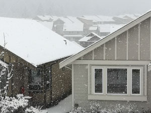
Snowfall began around 10 am this morning in the Greater Victoria area, with accumulation expected to be about 10 cm. By mid-afternoon the continued snowfall has contributed to snowy roads and changes to schedules.
Road maintenance crews usually start on major roadways first, working to lesser travelled routes after that. In the south island, Mainroad South Island will perform snow removal operations on highways in the region (Hwy 1, Hwy 14, Hwy 18) until the event passes, and until roadways are clear and back to normal.
“Winter chain up and M&S winter tire requirements are in effect,” says Mainroad.
As of noon, the temperature was hovering around zero, which means that freeze-melt action will contribute to roads being additionally slippery.
Classes have not been cancelled in SD62 schools in the west shore and Sooke. SD62 school buses will be running at the end of the school day. “Our buses have professional drivers, sand and chains to get students home safely at end of the day,” says SD62 Superintendent Scott Stinson.
“We typically don’t close schools early as we know parents aren’t always around to come pick their kids,” says SD62 communications rep Lindsay Vogan. “Students were safe and warm all day.”
Many parents did go and pick up their kids, but the ones who stayed had fun too. Secondary schools end early on Fridays and all elementary and middle schools will be dismissed by 3 pm today.
Winds at 11:15 am were gusting at about 17 km/h and up to 44 km/h by 2 pm, with a wind warning in effect: “Strong outflow winds gusting to 90 km/h will develop this evening over the Fraser Valley, southeastern Metro Vancouver, Greater Victoria and the Southern Gulf Islands. Any falling snow during the period of strong winds may result in reduced visibilities in blowing snow.”
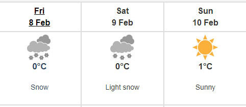
The strong winds and around-zero temperatures will persist on Saturday, says Environment Canada. Snowfall will continue through early this evening but “threat of snow’ will end by early Saturday morning February 9.
Near Nanaimo, heavy flurries may develop this evening resulting in snowfall accumulations of 10 cm or more in a short period of time.
Drivers are advised to prepare for quickly changing and deteriorating travel conditions. “Rapidly accumulating snow could make travel difficult over some locations. There may be a significant impact on rush hour traffic in urban areas.”
Environment Canada is on Twitter at #BCStorm.
Two vehicle accidents caused power outages in Saanich this morning after snowfall began, leaving 2,400 BC Hydro customers without power for a while (as of 1 pm). Out in East Sooke on Gillespie Road about five BC Hydro customers are without power (as of 2:20 pm).