


Monday November 15, 2021 | WEST SHORE & SOOKE, BC
by Mary P Brooke, Editor | Island Social Trends
Heavy rains continue on south Vancouver Island this morning. And very strong winds with gusts up to 90 km/h are still in the Environment Canada forecast.
These statements were part of a hastily arranged media session called at 8:45 am for 9 am this morning, with Public Safety Minister Mike Farnworth, Environment and Climate Change Canada rep Armel Castellan, and two Ministry of Transportation and Infrastructure senior managers: Janelle Staite (for the south coast region) and Paula Cousins (for the Interior region).
Travel on major routes affected:
As of 9 am this morning, three major highway routes are partially or fully closed on south Vancouver Island.
- Highway 14 is experiencing flooding near Impala Road in the Metchosin stretch is covered with water, and the road has been closed in both directions. This prevents travel between Langford an Sooke. A detour available at this time. Next update time Mon Nov 15 at 12:00 PM PST. [Last updated on Drive BC at Mon Nov 15 at 8:52 AM PST, next update at noon]. (DBC-35124)
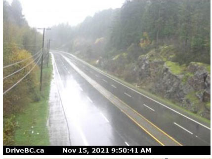
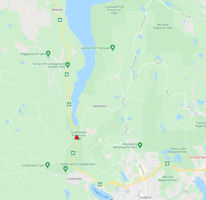
- Highway 1 Malahat. Road closed in both directions. Flooding between Finlayson Arm Rd and Wellswood Rd (Langford). Expect delays. [Last updated on Drive BC at 9:34 am, next update at 10:30 AM PST. (DBC-35138)
- Highway 1 southbound is closed due to flooding between Mt Sicker Rd and Somenos Rd (2 km south of Chemainus). [Last updated on Drive BC at 8:21 am, next update expected at Next update time Mon Nov 15 at 9:30 AM PST. Last updated Mon Nov 15 at 8:21 AM PST. (DBC-35132)
A less heavily used route in East Sooke is also impacted:
- East Sooke Road has flooding at Beecher Bay Road in the Sooke region. The road is closed. No detour at this time. Next update set for today at noon. [Drive BC last update at 8:47 am.] (DBC-35133)
Advising about safety first:
“If you don’t need to be out on the roads, stay home,” said south coast MOTI rep Janelle Staite. An added factor for the interior is the snow that is expected in late afternoon, said Interior MOTI rep Paula Cousins.

Public Safety Minister Mike Farnworth called today’s situation “dynamic”. As things change, responses will adapt. He noted at the top of his remarks that community water use is unavailable in Merritt in the Interior, due to flooding.


Wind warning:
Yesterday at 5:24 pm, Environment Canada issued a wind warning for Greater Victoria, saying that strong winds which may cause damage were expected or occurring this evening, through to today Monday November 15.
The hazard is described as strong westerly winds that will impact Victoria with gusts up to 90 km/h near Juan de Fuca Strait.
Castellan told media this morning that the same warning continues through today. He emphasized that winds of that strength are likely to topple trees, resulting in power outages in some or many cases.
“High winds may toss loose objects or cause tree branches to break,” it was stated in the standard wind warning last night.
“A sharp cold front stalling across southern Vancouver Island through Monday morning will finally move forward into Washington state Monday afternoon. In its wake, gale to storm force westerly winds will rise in Juan de Fuca Strait. Across most of Greater Victoria, winds will rise to 30 to 60 km/h. However, exposed coastal sections near the Strait will experience westerly winds of 60 km/h with gusts to 90,” it was stated in the wind warning statement last night.
People in affected areas are encouraged continue to monitor alerts and forecasts issued by Environment Canada. To report severe weather, send an email to BCstorm@ec.gc.ca or tweet reports using #BCStorm.
Rainfall warning:
As of 4:43 pm Sunday November 14 Environment Canada issued a rainfall warning being in effect for Greater Victoria, with 75 to 100 mm of rain by noon on Monday. That was updated to being 100 to 180 mm storm totals by noon today. Timespan: Sunday night into Monday morning.
This is resulting from a “significant atmospheric river event that continues to bring copious amounts of rain to southeastern Vancouver Island and the Southern Gulf Islands tonight and Monday morning”.

Today Castellan noted that rainfall in September and October was at 200% beyond average in some areas of BC. That much precipitation came on top of summer drought conditions, so the ability of the soil to absorb so much water at once is impacted; trees don’t have as much grip in the soil and are more susceptible to the impact of strong winds.
Most locations had already received 30 to 50 mm of rain beginning late Saturday. Heavy rain will continued last night into today, giving an additional 30 to 60 mm. It will ease late Monday morning as the system exits the region.
People are encouraged to continue to monitor alerts and forecasts issued by Environment Canada. To report severe weather, send an email to BCstorm@ec.gc.ca or tweet reports using #BCStorm.
Flooding on roads & other areas | Langford:

Heavy downpours can cause flash floods and water pooling on roads. Localized flooding in low-lying areas was stated yesterday as being possible, and this is in fact happening.
The City of Langford reports multiple flooding issues around town.
- Lodmell/Navy Court and Walfred at Lodmell
- Ernhill – road is flooded but passable
- El Paseo at Wendy
- Millstream Crek
- Bilston Creek
- Bear Mountain Parkway downhill lane just past the golf bridge – road is flooded due to the pedestrian stairway acting like a waterfall
- Bear Mountain Parkway downhill of Nicklaus – gravel outwash on road, still passable
- CRD Water has been called out to the lift station on Waldred Road
- Shaw at Arngask – Sinkhole
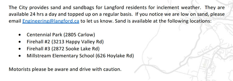
The City provides sand and sandbags for Langford residents for inclement weather, available 24 hours a day, topped up on a regular basis. If the supply seems to be low, email to engineering@langford.ca to let them know. Sand is available at these locations:
Centennial Park (2805 Carlow)
Firehall #2 (3213 Happy Valley Rd)
Firehall #3 (2872 Sooke Lake Rd)
Millstream Elementary School (626 Hoylake Rd).
===== LINKS:
Environment Canada – Greater Victoria wind warning for Nov 15, 2021
Island Social Trends Traffic Page