


Wednesday August 6, 2025 | VICTORIA, BC [Posted at 11:15 pm | Updated August 10, 2025]
by Mary P Brooke | Island Social Trends
Traffic flow on Hwy 4 may be interrupted based on BC Wildfire Service needs.
See: Wesley Ridge wildfire article from August 3, 2025 | Wesley Ridge wildfire article from August 5, 2025
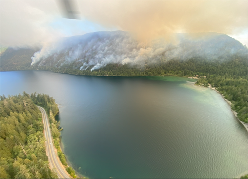
The Wesley Ridge wildfire (V71145) that started July 31 near Nanaimo is now 538 hectares in size (up from 511 yesterday, 389 hectares on Monday, and 245 hectares on Sunday August 2).
The fire is still out of control, said BC Wildfire Service today in what has become their daily briefing about this ‘fire of note’.
The wildfire is considered to have been ‘human caused’ (i.e. not by lightning).
Ministers today:
Forests Minister Ravi Parmar today reminded British Columbians about the campfire ban and about needing to be cautious in dry wooded areas. Current information about current wildfire details is posted on the BC Wildfire Service website, he noted.

Kelly Greene, Minister of Emergency Management and Climate Readiness said: “We know that we still have challenging weeks ahead for this week’s wildfire season.” She again encourages people to create a household emergency plan.

Fire of note:
The fire was designed a ‘wildfire of note’ yesterday and continues as such today.
That’s a designation which highlights a fire that may be impacting multiple people in the area.
The ‘fire of note’ designation doesn’t provide more resources to the fire but makes it easier for people to find information.
People can get information online in the BC Wildfire Service Response Section of the Full Details Tab (info about operations, resources, and info about the fire itself).
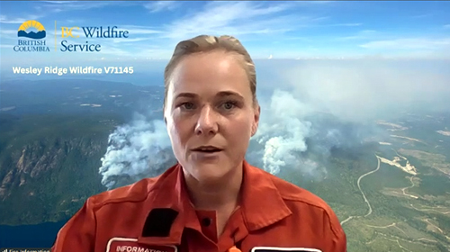
The Zoom call media session was hosted today by fire information officer Madison Dahl along with ESS information delivered by Douglas Holmes of the Nanaimo Regional District.

Fire location and size:
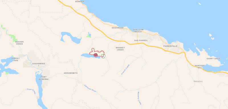
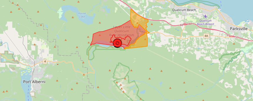
The fire is situated between Nanaimo and Port Alberni on central Vancouver Island. The communities of Parksville, Qualicum Beach and Dashwood are nearby.
Updates were provided about on-the-ground actions, evacuation alerts, orders and the reception centre for those affected.
Highway 4:
Highway 4 (which services traffic flow to and from Uculet, Port Alberni and Tofino) is open but drivers are asked to keep moving — do not stop, drive to conditions. Traffic conditions for Highway 4 and Highway 19 are available on DriveBC, including any closures and delays. Crews may be working alongside the highway so drivers are to proceed with caution.
Traffic control personnel will be on Hwy 4 at the Port Alberni Summit for eastbound traffic and Chatsworth Rd for westbound traffic. Traffic flow may be interrupted based on BC Wildfire Service needs, says Ministry of Transportation and Transit.

Smoke:
Visibility is limited at this time due to wildfire smoke.
Dahl said yesterday that the south edge of the wildfire along Cameron Lake is burning in “inaccessible and challenging terrain with large amounts of accessible timber”. As such, it is going to continue to produce smoke as the fire consumes fuels along the slope.
“Smoke will continue to be visible when the wildfire smoke and winds align,” said Dahl.

24/7 action on this fire:
There are now 185 personnel (up from 164 yesterday and 142 the day before) dealing with this wildfire, as reported today by BC Wildfire Services.
Tody that includes127 firefighters, 10 fallers, and 48 structural protection specialists.
There are 11 pieces of heavy equipment on the job and nine helicopters. Night vision helicopters worked overnight.

Water & ground safety:
Large scale water delivery systems are being established. Heavy equipment is working to establish control lines on workable ground.
A key goal is to create a safer working environment for ground crews.
Cameron Lake, Horne Lake and Spider Lake are being used by aircraft for water delivery. The Horne Lake boat launch is now closed, Holmes reported today.
“Stay clear of any aircraft there or on adjacent lakes,” says BC Wildfire Services, as any other lakes could also be used in the response effort.
Anyone on the lake should stay close to shore.
The aircraft “need plenty of room to maneouvre to do their job safely”, said Dahl in yesterday’s update, including for approach, filling and departure.
“Use common sense. Keep boats away from where tankers and aircraft are operating.” Boaters are to dock immediately if they see aircraft in the area. Interference to the aircraft means a mission would be cancelled for safety regions.
Drones are not allowed in these active areas.
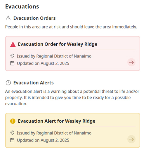
Evacuation orders and alerts:
There are now 87 residences on evacuation alert (down from 235 yesterday and 238 the day before). There are 250 residence on evacuation alert.
More information:
- Regional District of Nanaimo Current Alerts: rdn.bc.ca/current-alerts
- Emergency Operations Call Centre: 250-390-6538 (8 am to 8 pm)
- For re-entry information for evacuees, go to: rdn.bc.ca/wesleyridgewildfire
- BC Govt – Evacuee Registration and Assistance – 1-800-387-4258 Emergency Support Services | ess.gov.bc.ca
- To report a wildfire call: 1-800-663-5555 or *555 on a cellphone (download the app to send a photo with your report)
Visit the Qualicum Beach Civic Centre or ESS online:
People who have been evacuated should register at ess.gov.bc.ca or at the Qualicum Beach Civic Centre at 747 Jones Street, Qualicum Beach (tel: 250-752-1992) which is presently open 24/7.
Currently there are 509 evacuees have received ESS supports online or in person, said Holmes today (from 411 yesterday and 236 the day before.
The use of this lodging is for people who don’t have other options (stay with family or friends, or contact your insurer to see what other options are available), says the Nanaimo Region Operations director.
A pet trailer has been set up at the evacuation centre, with personnel to help take care of animals.
No donations at this time:
The good intentions of people who wish to donate food, clothing or other items is appreciated. But there is no space or people to handle and manage donations of goods at the evacuation centre.
So please don’t bring any donated items to the reception centre, said the Nanaimo Operations officer today.
Weather impacts:
Today’s high is expected to reach 25°C (higher than 24°C seen yesterday) with an relative humidity of 50% (same as yesterday). Winds are about the same as yesterday at 10 kph (with gusts to 20 kph), though today’s winds are from the west/southwest (yesterday from west/north-west with gusts up to 15 kph.
No rain is in the forecast for Tuesday though 2 to 4 mm is expected on Wednesday.
That’s still not enough. It will take substantial rainfall to make any difference in the action of this fire, acccording to BC Wildfire Service.
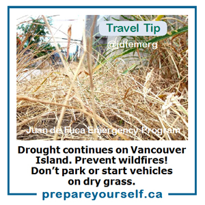
This is a period of drought on Vancouver Island; July was one of the driest on record.

===== RELATED:
NEWS SECTIONS: EMERGENCY PREPAREDNESS | VANCOUVER ISLAND | WILDFIRE MANAGEMENT | FORESTRY