Friday October 25, 2024 | VICTORIA, BC [Last update 1 pm on October 26, 2024]
by Mary P Brooke | Island Social Trends
As if this week hasn’t been tumultuous enough (BC election results uncertain) there will be strong winds tonight in the Greater Victoria region.
For overnight Friday (October 25) into early Saturday morning (October 26) Environment Canada is forecasting high southeast winds as much as 60 km/h gusting to 80 km/h (peak winds at 90 km/hr).
Gusts will be brief but strong. The strongest winds will begin near midnight and end by early Saturday morning, says Environment Canada.
That wind strength may cause tree branches to break. The District of Sooke suggests avoiding heavily wooded areas during high winds.
Power outages:
The forecast indicated that “power outages are possible”. But [ipdate on Oct 26] winds turned out not to be as strong as indicated, for most areas of south Vancouver Island.
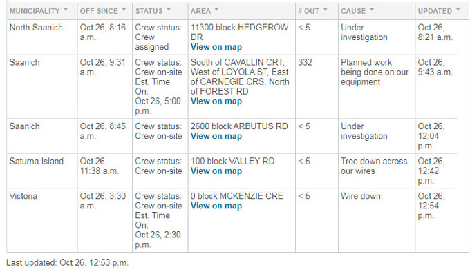
[Update October 26.] There were power outages due to the windstorm (now with power restored) in Saanich, Central Saanich, Metchosin/East Sooke (1,280 BC Hydro customers), Sooke (4,015 BC Hydro customers), Chemanius, Saturna Island, Gabriola Island, Ganges Island and Thetis Island.
As of 12:30 pm Saturday October 26 there are still about four storm-related power outages being worked on for restoration by BC Hydro, in North Saanich, Saanich, Saturna Island and on Piers Island.

Regional scope:
Environment Canada says this wind warning is for
- Metro Vancouver – Southwest,
- Metro Vancouver – Southeast,
- Greater Victoria,
- Southern Gulf Islands, and
- East Vancouver Island – Nanaimo to Campbell River
Rain over the weekend:
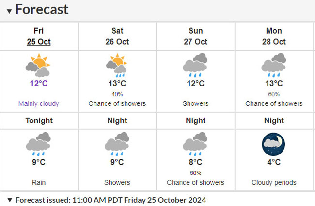
Rain showers are expected today through Monday, with temperature highs around 12°C to 13°C and nightime around of 8°C (reaching a low of 4°C on Monday night).
Ministry of Emergency Management and Climate Readiness:
The BC Ministry of Emergency Management and Climate Readiness has issued a news release today reminding people to prepare for seasonal weather.
The precipitation that is part of the upcoming storm tonight includes a note about “saturated ground conditions in low-lying areas” that could lead to reduced drainage and faster runoff.
Tonight’s storm is “anticipated to be weather than last weekend’s atmospheric river event”, the ministry stated.
===== RELATED:
NEWS SECTIONS: VANCOUVER ISLAND | BC ELECTION 2024 | EMERGENCY PREPAREDNESS & SAFETY


