


Monday March 9, 2026 | VICTORIA, BC [9:14 pm]
by Mary P Brooke | Island Social Trends
It sort of puts a damper on what was feeling like the start of spring.
Even as Victoria-area flower counting carries on, yes there is more low-elevation snowfall in the overnight forecast for the Greater Victoria area and south coast.
Some areas of Greater Victoria woke to light snow on cars, driveways and rooftops this morning. Expect a bit more of that tonight.
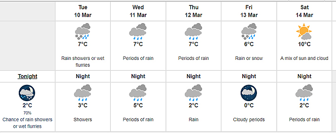
The Environment Canada forecast for Greater Victoria shows low-elevation snowfall for Tuesday morning March 10, describing it as “widespread risk” for a trace to 4 cm for areas near sea level.
For Wednesday morning there is “local risk over higher terrain and inland sections”.

Gardens may have to wait:
For people who were already eyeing their backyard gardens to plant the first veggie starter plants of the season, that will have to wait for perhaps another week.
Of course, people with backyard greenhouses will be happy to have that protection for their seedlings.

Hazards:
There is potential for challenging driving conditions; Environment Canada says to allow extra time for travel. Also to prepare for sudden reduction in visibility in heavy flurries.
Of course these ‘hazards’ are all relative for people who have driven in areas of the country where winter conditions include snow from about November through to sometimes April.

Is it spring?
Meteorological spring (a convenience for the weather industry) in the Northern hemisphere starts March 1 and runs to May 31.

Astronomical spring (more in rhythm with the planet itself) starts around March 20 or 21 each year at the Spring Equinox.

===== RELATED:
NEWS SECTIONS: WEATHER IMPACTS | GREATER VICTORIA | TRAFFIC