


Sunday July 11, 2021 | VANCOUVER ISLAND, BC
by Mary P Brooke, Editor | Island Social Trends
Drought is affecting much of Vancouver Island and southern British Columbia this summer, due to low spring rainfall amounts, as well as the recent extreme heat wave and record high temperatures in June and early July across the entire region.
Drought is a recurrent feature of climate involving a deficiency of precipitation over an extended period of time, resulting in a water shortage.
In British Columbia, drought may be caused by combinations of insufficient snow accumulation, hot and dry weather, or a delay in rainfall.
Drought can lead to reduced water availability for household and business use. Lower streamflows may cause warmer river temperatures, affecting fish and other aquatic life. Low streamflows can also have an impact on groundwater levels.
Planning for drought:
The BC Drought and Water Scarcity Response Plan was issued in May 2021, having been prepared by the Ministry of Environment and Climate Change Strategy on behalf of the Inter-Agency Drought Working Group. The plan includes information on pre-drought preparedness (provincial, regional and local).
As part of drought preparedness, local authorities’ responsibilities may include (see page 11 of the BC Drought and Water Scarcity Response Plan):
• complete a water supply and demand analysis, local drought management plans and
emergency response and contingency plans; update and practice implementation of plans
annually;
• establish water conservation strategies and water use reduction targets;
• implement water conservation programs; continuously improve water use efficiency;
• incorporate water conservation into planning and daily operations;
• municipal authority is required to enforce water restrictions. Local governments should
develop bylaws for water conservation, drought management and emergency drought
preparedness including water restriction stages and requirements to respond to low water
supplies.
Vancouver Island focus:
There is a five-level drought system, with Level 5 being the highest.
The East Vancouver Island Basin is at Drought Level 4 (red on map). At this level, adverse impacts on people or ecosystems are likely. Adverse impacts on fish have been observed, due to very high water temperatures combined with low flow conditions, dewatering of riffle habitats and disconnected side channels. Water conservation is being urged across the region to help reduce the risk of significant impacts on the environment or other water users.
The West Vancouver Island area is at Drought Level 3 (orange on map). Adverse impacts are possible.
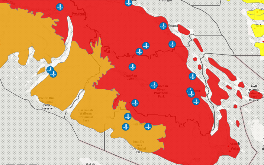
- East Vancouver Island is at Drought Level 4 (red on map – includes the Greater Victoria area) with adverse impacts possible.
- West Vancouver Island is at Drought Level 3 (orange on map – includes Juan de Fuca Provincial Park and beyond) with adverse impacts possible.
British Columbia ranks drought levels from 0 to 5, with Drought Level 5 rated as the most severe with adverse impacts to socio-economic or ecosystem values being almost certain.
Watersheds of concern:
Areas of particular concern for risk of additional impacts of water scarcity and drought include but are not limited to the following watersheds: Sandhill Creek, Koksilah River, Chemainus River, Millstone River, Tsolum River, Black Creek, Fulford Creek on Salt Spring Island, as well as the majority of the Gulf Islands.
The West Vancouver Island Basin, which roughly stretches from Cape Scott to Jordan River, is currently under Drought Level 3. Under these conditions, local adverse impacts to water users, fish or ecosystems are possible.
Many other watersheds throughout central and southern B.C. are also experiencing drought and water scarcity.
Water conservation by everyone:
Water conservation is everyone’s responsibility. Aggressive conservation is being urged for all areas affected by drought. Residential, agricultural and industrial water users in areas affected by drought should observe all water conservation bylaws, watering restrictions and advice from their local government, irrigation district or water utility.
Irrigators, water licensees and water users in watersheds with water scarcity should prepare and plan in case additional targeted water restrictions or temporary protection orders under the Water Sustainability Act are required as the summer progresses.
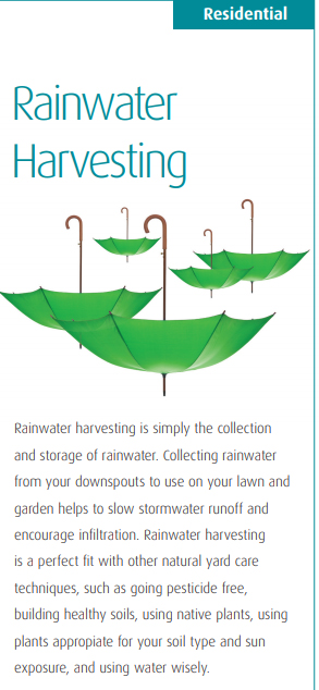
Rainwater harvesting is the practice of collecting and storing rainwater for future use, as outlined on the Capital Regional District website. It can be as simple as putting out buckets to collect rainfall for reuse in your garden, or more complex involving catching roof runoff. | Click here for the CRD Rainwater Harvesting brochure.
General water conservation tips:
At home:
- Limit outdoor watering.
- Do not water during the heat of the day or when it is windy.
- Consider planting drought-tolerant vegetation.
- Take shorter showers.
- Do not leave taps running.
- Install water-efficient showerheads, taps and toilets.
On the farm:
- Implement an irrigation scheduling program using real-time weather data.
- Schedule irrigation to match crop needs and soil storage capacity.
- Improve water system efficiencies and check for leaks.
- Focus on high-value crops and livestock.
Industry:
- Reduce non-essential water use.
- Recycle water used in industrial operations.
- Use water-efficient methods and equipment.

===== LINKS (from Ministry of Forests, Lands, Natural Resource Operations and Rural Development)
Drought portal (maps, tables, definitions):
https://governmentofbc.maps.arcgis.com/apps/MapSeries/index.html?appid=838d533d8062411c820eef50b08f7ebc
Drought information:
https://www2.gov.bc.ca/gov/content/environment/air-land-water/water/drought-flooding-dikes-dams/drought-information
Freshwater sportfishing regulations and angling closures:
https://www2.gov.bc.ca/gov/content/sports-culture/recreation/fishing-hunting/fishing/fishing-regulations
River Forecast Centre:
https://www2.gov.bc.ca/gov/content/environment/air-land-water/water/drought-flooding-dikes-dams/river-forecast-centre
Drought and agriculture:
https://www2.gov.bc.ca/gov/content/industry/agriculture-seafood/agricultural-land-and-environment/water/drought-in-agriculture