


Friday January 31, 2020 ~ GREATER VICTORIA [Update with additional shoreline advisories at 11 am February 1, 2020 — see section below]
by Mary Brooke ~ West Shore Voice News
Today January 31 — in the middle of winter –– we had the warmest January 31 on record for the Victoria region, with a high of 14°C.
This warmth and a lot of rain — between 100 and 150 mm overnight into Saturday — comes thanks to one of those Pineapple Express
subtropical moisture weather patterns.
Since last night 80 to 150 mm of rain has fallen over West and Inland Vancouver Island says The Weather Network. “Additional rainfall amounts of 30 to 50 mm are expected tonight. Rain will ease early Saturday morning as the system exits the area.”
Rainfall warnings are in effect with the heightened risk of localized flooding (including water pooling on roads) and even flash floods on roads.
Localized flooding in low-lying areas is possible.
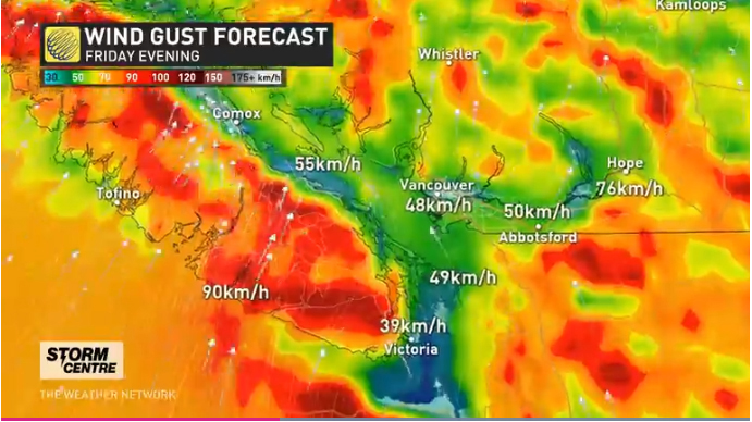
There has been wind as well — southwest 40 to 60 km/h becoming west 30 gusting to 50 before morning. This helps contribute to conditions where the soil is softened by the heavy rainfall and winds can more easily push over trees or cause limbs to fall. This often leads to power outages.
As of 11:30 pm this evening there are 2,876 BC Hydro customers on South Vancouver Island without power (26 outages). Almost all of the outage tally is in Duncan and on the Gulf Islands, although also with 593 down in the Sooke area (crews are assigned but not yet on site).
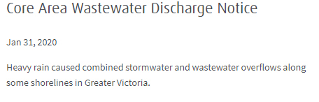
In some shoreline areas of Esquimalt and Oak Bay there was some rain overflow contamination (mix of stormwater and wastewater) this morning, with advisories from the Capital Regional District. The areas affected are between Fraser Street and Victoria View Road including Macaulay Point in Esquimalt, and also between Trafalgar Park and Radcliffe Lane including McNeill Bay in Oak Bay. As a result of these discharges, residents are advised to avoid entering the waters along the affected shorelines, as the wastewater may pose a health risk.

========== FROM CRD – UPDATE FEBRUARY 1:
Heavy rain caused combined stormwater and wastewater overflows along additional shorelines in Greater Victoria through the night of January 31 and into this morning February 1, 2020. The full list of affected areas:
· Between Fraser St and Victoria View Rd including Macaulay Point in Esquimalt.
· Between Radcliffe Ln and Cook St. including McNeill Bay and Gonzales Bay in Oak Bay and Ross Bay and Clover Point in Victoria *NEW*.
· Between Currie Rd and Cattle Point Lookout Rd including Willows Beach in Oak Bay *NEW*.
· Between Tarn Pl and Seaview Rd including Cadboro Bay in Saanich and Oak Bay *NEW*.
· Between Arbutus Cove Ln and Telegraph Bay Rd in Saanich *NEW*.
As a result of these discharges, residents are advised to avoid entering the waters along the affected shorelines, as the wastewater may pose a health risk.
As a precaution and in consultation with Island Health and the local municipalities, beaches within the affected areas will be posted with public health advisory signs until sample results indicate enterococci levels are below the 70CFU/100mL recreational limit.
Check the CRD website for updates.
===== Links:
Current weather [The Weather Network] – Victoria | Langford | Sooke